
Tiritiri Track – Shakespear Regional Park
From the carpark at Te Haruhi Bay, this multi-use track heads along the sand dunes, past the campground and an old Maori settlement area at the eastern end of the bay. Continue along the cliff line for the best view of Tiritiri Matangi Island. This is a very popular track and takes in a variety of environments and ramps are installed at every gate. You may encounter farm animals on this track. Follow the red markers. 4.8 km 2.0 hours(Source)

Tiritiri Track (shown in red)
I had never ventured “as far as” Shakespear Regional Park prior to the day that James and I (well more I) decided that we’d cross the bridge and run a loop of the park. Not that Shakespear is a vast distance away (in the scheme of things), it’s just that the tip of the Whangaparaoa Peninsula isn’t the quickest place to get too – from anywhere.
As it’s a long way for us travel, I investigated the trails online before going and we (well, I) decided that if we did at least 3 of the 4 tracks in the park it would be worth the 50-60 minute drive to get there.
We parked outside the Information/Ranger Station and picked up a map before setting off, which was fortuitous as unlike in the Waitakere Ranges the signage was few and far between, instead Shakespear Regional Park utilizes color coded poles to mark the way (a great majority of which we found lying on the ground as we guesstimated our way around the park).

I’m not sure what I expected, but I soon found out that Shakespear Regional Park is a series of muddy farm paddocks (complete with farm animals) linked together by gates and although the map insinuates that there is bush on the Tititiri track (denoted by the dark green areas), apart from a tiny pocket of trees just after the campground the rest of “track” is open pasture.
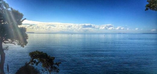
I will say that the views are amazing, however because it’s open pasture with very little shelter the wind was deafening on the morning we were there. It was also wet underfoot – very wet! Although you do tend to get that on coastal tracks because there is very little in the way of protection from the elements – in winter it’s knee deep mud and in summer you risk death by heat exhaustion!
But the views!

The track itself isn’t defined (as such) until you reach the junction where the Tiritiri & Lookout Tracks meet the Heritage Trail. Prior to that point it’s a case of scanning the land ahead for a colored post. As I mentioned earlier a lot of them were lying on the ground but enough were standing that we could see them far off in the distance and we’d just head towards those (passing the fallen ones en route).
I bet the cows did it, they looked pretty menacing to me ..

We did the loop in an anti-clockwise direction which meant that 2/3rd of the trail was an ascent, with some sections being very steep (in that I couldn’t run them – even when James told me the marauding cows were after me). It does (somewhat) flatten at the top near the defence force land and descends back to the driveway after passing the lookout, but it would definately be an easier run if you completed the loop in a clockwise direction.

The lookout was a distinct highlight, there is even a picnic table should you wish to stop for a spot of lunch!
And the views!
The other stuff;
Location – 1468 Whangaparaoa Road, Army Bay (50km from the CBD)
Directions – From Auckland, head north on the northern motorway (State Highway 1) and take the Silverdale off-ramp. Drive through Silverdale and turn right onto Whangaparaoa Road. Follow the brown Twin Coast signs to the end of the Peninsula.
Parking? – Yes, we parked at the information office but there is another car park further down the driveway near the camping ground.
Toilets? – Yes, near both car parks.
Kid Friendly? – Yes, unless they have a fear of large cows – although it is quite a trek for little legs and in winter the mud could very well be at least knee deep in places.
Till next time