
The Perimeter Track – Wenderholm Regional Park
Walking Track – The Perimeter Track takes you right around Maungatauhoro through areas rich in Maori history and beautiful forest before descending to Kokoru Bay on the Waiwera estuary. The track is steep, unformed and of tramping track grade only on the descent to Kokoru Bay. Follow the red markers. 4.0 km. (Source).

Perimeter Track (shown in red)
In my entire 40 something years on this earth I’ve visited Wenderholm Regional Park less than a handful of times, all of which were back when I was a child (of perhaps Isabelle’s age) and never before have I ventured along any of the trails in the park.
James and I had originally planned on heading down to Waihi over Labour Weekend to run an Xterra Race but at the last minute the race organisers were told that no vehicles could park at the event start/finish and that everyone would have to bus in. Neither James or I were keen on that so we decided to have a “staycation” in Auckland.
Since James is keen on seeing more of the country and I hadn’t been to Wenderholm since I was a kid we headed across to the park early on Saturday morning.
We parked at the end of the driveway (rookie mistake) but it did allow us to pick up a map from the information “center” (a small brown shed with a notice board and free maps). Once again picking up a map was rather fortuitous as the tracks aren’t extremely well signposted. I mean honestly – what’s with these color coded poles placed behind large trees they like to use as direction markers on the North Shore?

If you’re as shit at reading maps as I am then FYI all of the trails (bar the Te Akeake Walk) start at the Couldrey House. Follow the white shelled path veering left past the large statue (stop and check out the back side of him, it’s awesome) and continue along the path up to the driveway. At this point the Perimeter Track runs left and right.
We decide to turn right to complete the loop in an anti-clockwise direction as James (after glancing up at the cliff from the beach) made an educated guess that it would be an easier climb that way.
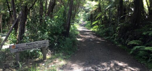
En route, you’ll pass the entrance to the Couldrey House Track (on your left) which you’d assume would be well you know, actually near Couldrey House, but you’d be WRONG .. lolol. You’ll run under these amazing orange tinged (and huge) trees, past a toilet block and then if you look behind a random large tree you’ll come across the Perimeter Track sign and a shoe cleaning station a short way on.

Like I said, they aren’t big on making these trails easy to follow over here on the North Shore. 😉
From this point the trail climbs upwards but it’s more akin to large steps (in that it ascends, flattens out, descends and the ascends higher). I will say that on this section the signage is weird especially when at one point where you reach a junction and the only marker sign in sight is pointing in the direction you just came from .. WTF?
I looked right and saw a gate so choose to turn left (which ended up being correct). James couldn’t work out why I was confused but well you know, it’s a tad disconcerting when the arrow doesn’t point the correct way!
It’s truly breathtaking though, James and I both agreed that this is the most beautiful trail we have been on in the Auckland Region, not that James has been on that many but I’ve been to Omanawanui, the so called “jewel in Aucklands crown” and in my opinion this beats it hands down. There were even points where I’d be running and as I rounded a corner I’d want to stop just so I could take it all in (as opposed to stopping because I can’t breathe, which also happened on the uphill sections). 😉

The trail becomes a steep tramping track after the Waiwera Estuary. It was at this point that I was glad we traversed the loop in an anti-clockwise direction. Even though the ascent was lung busting, my knee would have struggled descending this section and even more so if the ground had been wet (which thankfully it wasn’t on the day we visited).
There is even less signage on this section so keep your eye on the trail, we came across a woman who ran straight past us (in completely the wrong direction) thinking she was still on the trail. Don’t worry we didn’t let her wander off into oblivion. I told James that was the advantage of being with someone as slow as I am, it’s hard to completely wander off the trail when you’re not travelling at super sonic speeds.

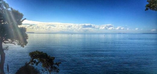
The last section is designed for the masses – it’s all boardwalks and stairs (which is my least favorite surface) BUT it’s so pretty that even I had a hard time hating it and the view from the cliff ..
AMAZING!
I think many factors came together on the day that helped push this trail to the top of the favorites list. The sun was out, the trail wasn’t busy (thanks in part to going early), it’s steep but not too steep. It’s near the beach so I get to paddle around in the water to cool down (post run) and James drove .. (oh and bought coffee).
What more could you want?

The other stuff;
Location – 37 Schischka Road, Waiwera (48km from the CBD)
Directions – Take the Orewa/Waiwera exit (394) from the Northern Motorway (SH1), just before the toll motorway commences. Drive north along the old state highway and enter the park on the right, just north of Waiwera.
Parking? – Yes – we parked at the end of the driveway (near the boat ramp) however I’d suggest you park near the entrance of the park as it’s an easier (and quicker) access to the Perimeter Track.
Toilet Facilities? – Yes, three in the park.
Kid Friendly? – Perhaps, although it’s quite short (km wise) it’s a decent walk (time wise) so I’d probably go along the trail in a clockwise direction stopping at the look out.
Till next time