
Kaitoke Hot Springs Track to Mt Hobson
Mount Hobson is the highest mountain on Great Barrier Island, rising 621m above sea level. There are three routes that you can take to stand at the top of Mount Hobson, this is the longest of the three ..
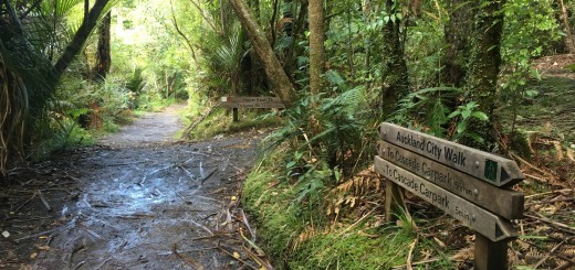
Kaitoke Hot Springs Track;
(3.5km)*
From the car parking area on Whangaparapara Road (which has toilet facilities), the trail to the top begins flat and easy along a well maintained gravel path. There is a large bridge not far from the start (approximately a 2 minute jog) and long boardwalks that take you through (or should I say over) the Kaitoke wetlands. 30 minutes later, you’ll find a somewhat randomly placed port a loo and the track reaches the hot pools a short distance later.
The Kaitoke Hot Springs are a natural, sulfuric series of pools dammed at a fork in the Kaitoke Creek. Here you’ll find a couple of bench seats and a picnic table (along with the usual information boards), if you follow the path up the hill you’ll reach a series of dammed pools. Although we didn’t stop for a soak (the plan was we’d do that on our return), I did stop to see how hot the water was and I found it to be similar to a warm bath for kids – I prefer my bath hotter.
To continue to the summit, cross the bridge and ascend the first set of approximately one billion stairs that will follow! From the top of the stairs it will take approximately 15 minutes to reach the Tramline Track North. (Less if you are not shite at descending stairs like I am).
Tramline Track North;
(1.4km)*
Once you reach Tramline Track North (which runs both left and right) you have the option to loop back to Whagaparapara Road by heading left (you’ll need to cross the stream) and following Tramline Track North to reach Forest Road, which will take you back to the road (further along than where you started), to reach the summit you veer right and continue along what I think was the nicest section of all to run along.
Tramline Track is a wide dirt “road” that was used by The Kauri Timber Company to deliver timber from stands as far away as Palmer’s Bush through to Whangaparapara. The tramway was closed in 1941 and now it’s one of the most visited sites on the Island.
Although the sign at the junction states it’s a 30 minute journey to Peach Tree Track even after stopping to read the information boards we did it in half that time.
Peach Tree Track;
(4.1km)*
Peach Tree Track is much narrower than the previous two trails and it starts out as it means to end, in an ascent!
Honestly I don’t remember much about it apart from it’s steep – long and hot .. in fact it’s where “that” photo was taken. The one I told James to send me if I ever suggested we run up another mountain “for fun” lolol although in saying that, my favorite part of the entire journey was wallowing in the icy cold stream that you cross about 1.3km before reaching the South Fork Track, (which incidentally was before I saw the fresh water lobster I’d been sharing the pool with crawl back to his wee cave under the rock where my feet had been).
The Sign at the beginning of Peach Tree Track stated it would take 1 hour 30 to reach South Fork which for us was about right even after stopping to cool off at the stream and my constant stopping to lament about the number of stairs I could still see ahead of me lolololol.
South Fork Track;
(1.50km)*
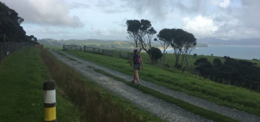
From Peach Tree track, South Fork heads left to reach Forest Road or right to head towards the summit of Mt Hobson. Mt Heale Hut is located a short distance ahead and it’s worth the slight detour to check out the view from the deck. You can also top up your water bottles and use the toilet facilities.
The section of track between the hut and the large slip (caused by the June 2014 storm) is very narrow and extremely technical – you’ll even have to clamber over boulders but it’s also one of the most picturesque parts of the trail. After the slip the climb to the top is extremely steep and there are stairs, stairs and yet more dam stairs.
The views are amazing, but do you know what annoyed the f**k out of me? There is no trig .. no trig! Every publication I had seen showed photos of happy people in front of the Mt Hobson trig – how am I supposed to take my “I bagged a trig photo – with no trig?!?!”
I’m sure that’s against the fair trading act .. 😉
As I mentioned earlier, my favorite part of the journey was the ice cold pool of water that I inadvertently shared with the fresh water lobster on the Peach Tree track. Thankfully no one walked around the corner as I got changed into my shorts – I did yell, I’m naked don’t come around the corner yet.
When I asked James what his favorite part was, he said “when we stopped to eat at the hut” ..
It’s the simple things I guess.
Till next time

*Distances as listed as per my Garmin data on the day of our trip.